About CEWITT
Objectives:
The CEWITT project aims at developing an innovative wireless tag with the objective to ensure the integrity and cost effectiveness of Pay per Use parking & Identification of free parking slots applications in Urban Areas.
The optimization of EGNOS / GPS capabilities, map matching techniques, correlation with radio signals and the development of specific algorithms working on EGNOS corrected pseudo-ranges and pseudo range differences will allow maximizing the level of accuracy and integrity needed in the applications.
The parking applications to be developed within the CEWITT project will rely of the same generic system architecture which is presented in the figure below:
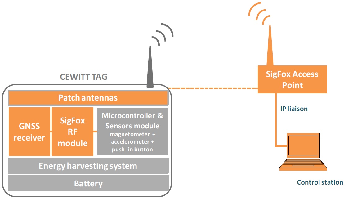
• The generic CEWITT tag architecture
The CEWITT tag will combine a magnetometer, an accelerometer, a push-in button, a micro-controller, a GNSS chipset, patch antennas as well as the wireless communication module. It will also include a battery and an energy harvesting system to allow lengthening the system lifetime.
The CEWITT tag will allow retrieving time stamped and geo-positioned sensors information when at standstill. It will wait for another event to arise to transmit another signal: for instance, when the asset is moving again. CEWITT tags will have built-in motion sensors that optimize power consumption resource by controlling the transmission trigger and intervals.
• Data collection and transmission on the telecom network
The CEWITT tag sends a brief signal for any new event arising, adding GNSS derived localization and timing, as well as sensors derived data. The signal is received by the nearest SIGFOX wireless Access Point and is sent to a Control Station via an IP liaison. A GNSS chipset is also included within the Access Point.
The Control Station determines the tag identity, sensors derived data together with tag location and timing coordinates, and sends this information to the CEWITT Web Platform.
The CEWITT platform merges such sensors and GNSS related data with information from other tags and/or pre-existing asset data, to provide valuable context. This is from such a platform, that the two following parking applications will be built.
Application 1: Pay-per-use parking
Drivers will have the possibility to subscribe to the CEWITT pay-per-use parking service, and by doing so, they will benefit from a more interesting price than if they had to pay at the current parking meter system. Moreover, with the CEWITT system, they will be billed under a pay-per-use system, as a function of the number of minutes they really park. For that purpose, they will be given a CEWITT tag to be positioned on their cars’ screen. Once parked, the user will press the push-in button of the tag in order to indicate his willingness to pay for the parking. At that moment, the CEWITT tag will then transmit the localization and associated timing information to the Control Station via the SIGFOX network. An automatic data processing will be undertaken in order to check that the user is well positioned onto a paying parking zone. If this checking is positive, the parking minutes counter will start.
As soon as the same tag sends the information that the car is moving (this moving information is derived from the accelerometer into the tag), the payment process stops. At the end of the month, the user is billed on his bank account for all its parking bills he had asked for with his push-in button. On the bill, a detailed justification is given with all the areas and associated timing he is charged parking for.
Application 2: Identification of free parking slots
For this application, CEWITT tags will be packaged into resistant shells and screwed onto the parking slots surfaces; thanks to the magnetometer inside, the CEWITT tag will be able to detect the arrival / departure of a car onto / from the parking slot. This departure or arrival information will be immediately transmitted to the control server.
When arriving close to their final destination, users of the CEWITT ‘parking slot identification service’ will be able to locate empty parking slots available through a web based service accessible via their smartphone. Then, one routing algorithm will guide them towards the available parking slot.
Other useful information to the municipalities could also be extracted thanks to GNSS timing features such as:
• the occupation rate of the parking slots which can be compared to the revenues generated in order to quantify the losses induced by parking smugglers, but which can also be derived to understand the parking flow,
• the parking slots which are occupied but with no payment process in progress when application 2 is combined with application 1 in the same streets.
It should be stressed that the CEWITT system is not intended to be used in indoor parkings but rather in street and aerial parkings. Indeed, studying the specific problematic of indoor localization is not included in the scope of this project.